June 7, 2010

Ring-Callaghan Ski Traverse


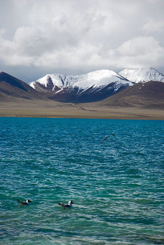
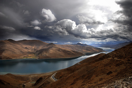
Ring Mountain Summit
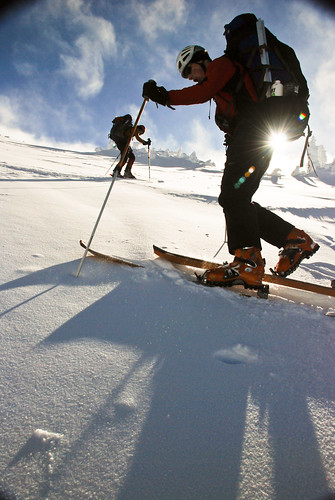
Two vehicles from Squamish Valley side approaching Ring-Callaghan traverse: Piotr, Anne, Adrien, Len and I, second vehicle, Jordan, Bram, Champagne and Julian, drove up to Upper Squamish Valley 50+km of logging road and stopped by Sliding Alder over grown on the access road. No luck seeking a clearance we parked at just below 1000m elevation and boot packed at 11am. We managed to find continuous snow about kilometer and half in over grown logging road. Len showed us bushwack efficiency with his multipurpose ski goggles and A-frame ski carry method, topped off with some momentum.

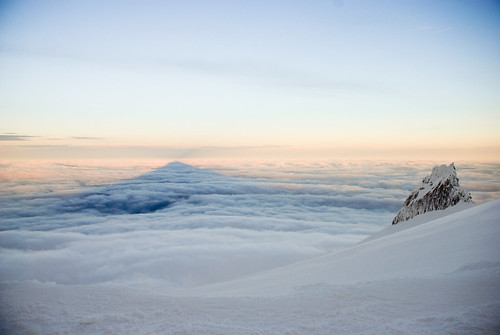
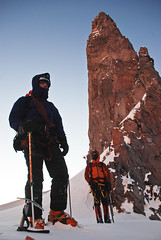
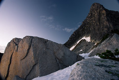
The morning clouds cleared and the day has been roasting. minimum sleep and Moonshine hangover had made the Friday night party go-ers a slog up the hill in the sun. We huff and puffed up Ring Mountain true summit at 5:30pm. The panorama view atop was gorgeous and skiing down was pretty fun on the corn snow. A couple of wet sluff avalanche size 0.5 - 1 has been observed.

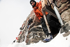
After we picked up our packs, traversed over to the East side of the Ring and gained access to Callaghan Glacier via a col West of Callaghan false summit, Arrived at camp north of the false summit at 9pm, only finding the opposing party has yet to come.

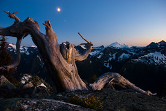
Some of us went for the false summit to see the sunset. while others use the last sun to setup camp and cook dinner. The other party arrived just after 10pm. A big chilly for June weather, mild wind chill probably around -5C and most of us only brought shoulder season insulated jacket. I partially wrapped my sleeping bag to stay warm and cooked in the snow kitchen.

We went to bed at 11pm in the Tarn 3 and It was pretty warm 8 hrs of sleep.

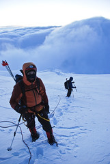
Overcast in the morning, took us 1 hr to get ready to bag Callaghan, pretty casual start. It was pretty icy on the short approach, I struggled to get my climbing skins to grip on side hill traverse. We took off the skis to bag Callaghan, back to camp to pack up around noon to head out towards Callaghan Lake, while Jordan, Bram, Champagne and Julian went back to Ring direction. Len had serious skin glue problem, large chunk of glue sticking to the ski base. After some white gas and scrapper treatment, it was good for until use the skin. so he just use the glue as kick wax.

Sunday was overcast. We attempted to get out by traverse a ridge system on West of the upper Callaghan Lake but a brief white out has abandoned our ambitious plan. So we generally followed the opposing party's up-track, but the visibility improved short after. See the markup Google Earth

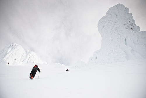
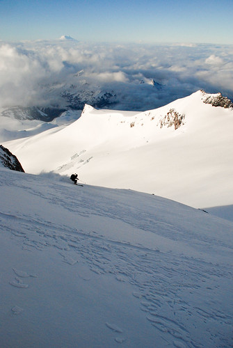
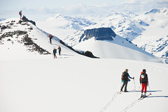
Plenty of thigh-burning tele turns were had in our group (4 tele 1 snowshoer). I could do 10 of those with my semi heavy pack before I had to put on this grim expression to pull off another two, then a really long one (couldn't get back up from low stance because exhausted thigh muscles), then a huge paramark turn followed by straight lining. We had lots fun making turns on the corn snow. It was one of the greatest Spring skiing I have had. Skied down to Callaghan Lake and traversed west bank to the south end.

By then we were all pretty tired and finding ourselves on the wrong side of the creek that drains the lake with the logging road visible across from us. My foot were burning inside the boots anyways so we waded across the creek, mostly ankle deep but got to past my knee at the end. Cold water creeped into the liner, it was rather a exhilarating to the feet. Then the fun part - XC the rest of 7km in oozy boots.

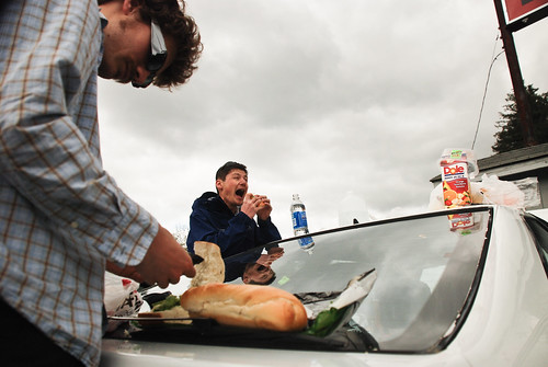
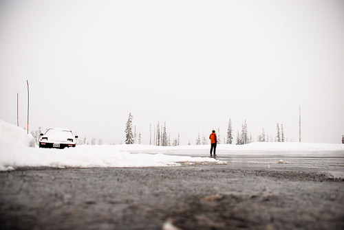
We made it to the get away car at 6pm. Enjoyed the pre-placed clean cloth and sandals. Piotr and Anne had a bath in the creek. We drove off for Shady Tree for well deserved feast and car swap.

Great times.
More Photos  Google Map

May 24, 2010

Wedgemont Attempt III - James Turner Tent Time

Third time trying to find a perfect weather with perfect people to climb some routes on Wedgemont area, this time we have a little more time so planned to hit James Turner, 10km east from the lake. by Needle Glr.

Boot packed with skis, technical crampons, some ice screws, four pickets, rope lots draws and protection, tent. we slowly booted up to Wedgemont Lk, camped by the outlet where water was and early started Sat with low ceiling at 6am heading towards Wedge-Weart col. The storm came in just after we got up Wedge glacier and couldn't see anything. carefully GPS navigated to WW col and decided to camp there and not going to JT in this pace of white out navigation. Sunday was forecasted a sunny day so we could just bag Wedge via NE arete. We napped from 2pm to 7pm, fried up spam with a cup of butter, black beans and rice for dinner, a little over salty but it was delicious. slept from 10pm until early morning to check weather at pretty much every hour. No sign of improvement so we kept on napping and waking up to 9am.

We got about feet and half new snow, gorgeous mid weight powder. it started to get brighter so we thought the condition was finally matching up the weather forecast. packed up and give NE arete a shot but didn't get very far. condition got worst and we pulled the camp and went for sweet sweet powder skiing down Wedge glacier back to hut. it was one of the best skiing of this season, no need to mention this is late May! We stopped by the Lake Hut to see party of 12 bailed out and only had a party of 2 up there to spend a night. We started to head down at 4pm and skiing down hugging the trees along the open drainage to tree line was sweet steep. some crust tree skiing down to about 1400m, past the avy pass by the creek, we started boot pack again. After some gruesome knee bashing boot pack down steep loamy trail. We got to car about 7:30pm, had victory beer of Twilight from Oregon and happily hit the high way to come home. Highly worth the boot pack even with mtnr gear for the powder slaying !!

My camera started to buzz during the storm and won't store pictures. settings on the LCD all jumping crazy numbers, can still take photos but won't save. I wonder if it had something to do with the storm or just being regularly 'wet'?

Only so little photos.

May 10, 2010

Getting High in the Cascades

Ski Mountaineering Mt Hood and Mt Rainier


Like many good adventures, this one starts out with some objectives in mind, and ends with something completely different. Skyler, Ran and I were planning to climb as many Cascade volcanoes as we could in 5 days. Our trip was inspired by knowledge of Mike Duncan et al. who were planning to climb Mt. Hood and maybe some others. For means, we chose ski mountaineering and for ends, we decided on Oregon's Mt. Hood (3428m) and Mt. St Helens (2549m) as well as Mt Adams (3743m) in Washington.


We left Vancouver Friday morning around 6am heading down towards Portland, by the afternoon, we arrived the Mt Hood Ranger Station in Zigzag, 20km East of Sandy, to get information. We were informed that a snow storm was taking over the region. That evening, we pulled in Camp Creek campsite to stay for the night, or maybe two or three nights awaiting for a good weather window.

It rained pretty hard through the night. Waking up Sat morning soggy, we decided to yo-yo skiing Mount Hood from Timberline Lodge. After got some coffee in Government Camp and heard that Hood is still in full-on mid Winter condition with 2 feet new snow, we were pretty stoked for the condition.

Arriving at the 'Climber's Cave' - which is a sheltered corridor with map and info for climbers of Hood - We soon put on ski outfit and headed out to find this snowcat trail leading towards top of the chairlift, so we know where to start in the dark the morning of the ascend day. It turned out, 40-60kmh wind with ice pallet scouring my face and merely 5 meters of visibility really not good enough for yoyoing. A snowcat sneak up on us within 10 meters and started to beep, when you turn your head around to see this giant machine with bright and mean headlights poking out of whiteout so close to you, really scary.

Skiing down and slalom around the trail marking poles was fun. We spoke to some Arc'teryx wearing local guide, he told us the cloud sometimes clears up at higher and recommended us to give it a try the day after as it would be the best weather window of the week. We agreed.

We hit the sack early to plan a early rise. After cold breakfast we drove up Timberline and hit the trail one hour after we woke up. A little windy but the clouds are deceasing as we climb higher. Just a little more than an hour and half we got about the same elevation as the top of the chairlift, the moon was high and bright, we turned off our headlamp and kept moving to stay warm. We left skis at an icy slope just before gaining to the Crater Rock, put crampons on. Wind was still gusting to around 40k which isn't bad, it was just cold and so dry that my nostril hurts inhaling air. My hands went from cold to numb then hot and burning pain, my camera battery went from full bar to 1/6 and blink. wouldn't auto focus or take photos.

As the sun was rising we got stoked to see the rim ice covered summit ridge. the shadow Mount Hood cast in the sea of cloud afar truly signatures the Cascade Volcano experience.

After passing a large guided group at Crater Rock, we soon picked on a variation of an Old Crater chut next to the Pearly Gate, as it has been congested by rime ice and not climbable.

We reached summit after boot packing up a 45deg slope with fresh snows. not technical but exhausting. fooled around on the summit ridge in high gust wind but warm in the sun.

Skied down to the Timberline Lodge by noon and napped by the fire pit while drying out our gear. Later we drove out for a treat at Rendezvous in Zigzag for a glass of Ice Axe Pale Ale from Mt Hood Brewery.

The next day, we drove into Portland for information and had picnic in a street park near water front. The sun came out, we exploded out our damp gear to let dry out - it had been a few days soggy camp to wait for a good weather! Considering the weather around Mt St Helens and Adams. We were looking at Mt Rainer for a better weather.


Mount Rainier

Tuesday, after getting food and fueled up, we drove up to Paradise Lodge, spoke to the rangers to get update condition for Muir and Rainier Summit. We saw a posted weather information in the ranger station, the table indicates such data: "avg smt temp, wind, etc." in tabular format, on the row "May 3rd", the cell shows "0 deg", "40". We were like "Oh that's pretty mild up there!" but until the ranger asked, "you guys from Canada aren't you?" We suddenly realized it was 0°F and 40mph, and asked ranger to look up what it is in Metric, it was -19°C and 64km/h, so wind chill, if you care, it would be -34°C, frostbite in less than 10 min.

It was classic to experience that dead silence in the trio for that awkward moment of 3 seconds. We drove up to the 24 hr use washroom, which has a corridor to shelter storm. This time of the year is shoulder season and not very many people up there. In the next 4 hours afternoon, we ran into four rangers and a couple of guides doing 'Denali' training with their clients up at Panorama Ridge, total of 20 people only 1 woman came in to use woman's washroom.

So I set up my bed inside the woman's washroom since it does not have urinators so it got a huge space for women to line up for stalls. Took forever to find the light switches, or not finding it at all because the lights are motion sensors. So that works out nice. I cooked yummy chicken curry and rice to fuel up for the grind to Camp Muir early morning.

Calm and crisp cold morning of Paradise. We set off with a cold breakfast with so so visibility. It cleared up as the sun got up, it was beautiful at Panorama Ridge. As we quickly got on to Muir Glacier and Mt Rainier summit cleared out of the cloud. I stared at it while skinning up and saw a big puff of white cloud shooting down Nisqually Icefall on south face of Mt Rainier. A second later hearing a deep rumble as the avalanche got bigger down the icefall. We were miles away from the reach of the avalanche but the magnitude of this class 4 avalanche makes me want to just run away for safty! Soon after the summit was surrounded in dust cloud and we heard a couple more of avalanche but could not see it. A cold air minutes later with ice crystals blew through us.

Visibility dropped to 100m as the day progressed. We could follow some wands only a couple of inches sticking out the snow. We knew the bearing was pretty much dead-on North so we just kept on going and seeing the wands.
The sun was in and out, but the radian heat was great, so the outside with breeze was warmer than inside the stoney hut, which we had it all to ourselves.

The door of the Muir public shelter was much of a representation of a bomb hatch. with doors and windows much like that of a ship. Solar panels on top to power the emergency radio. The floor inside was full of ice. There were a small bench area for 4 - 5 cooking at same time but most area are beds, probably sleep for 20 and it will be crowded.


We made dinner with fresh ingredient and slept at 7pm. after buried the sun silo and a window we dug out for lights. Just to get up at midnight for a pitch black moonless navigation in the serac fields!

I was half sleep for the next 5 hours, it felt like the longest night. The ranger and some of the Denali training guides came in at midnight to sleep, which was the time we were getting up to get ready. It was clear out but a little windy. Not too cold but I didn't feel warm wearing 6 layers pants and jackets. No moon, we could see some stars. it was pretty dark. We put on our skis headed over to gain the Cathedral Gap.

It was heavy breathing for maybe 100 meters of elevation gain to cross the Beehive, a little steep and rocky near top of the CG so we boot packed to save effort. The other side was the Ingraham Glacier, so we hugged the rock wall to skiers left to stay high and avoid glacier. Thinking the snow would be pretty wind affected and icy, we left skis there. We couldn't really see what we were avoiding but trying to stay not-so-scared of the big crevasses theoretically to skiers right and lower down We had some navigation confusion as we needed to boot pack very steep slope, which seemed leading to a rock face. but after dropped lower elevation to almost glacier level, the apartment sized seracs and highway width crevasses started to emerge in the dim end of our headlamp, we screamed the loudest as our inner voice can go, "Go up, Go back up! sh!t".

The snow was about ankle to shin deep, boot packing at near 3500m took quite a bit breath out of us. I was ahead for every 20 steps to catch up breath, repeat until I warmed up my hands and toe, then someone else.

We got to the steep part of the Ingraham Direct route where the route narrows and the slopes steepens to about 40 degree. We dug a pit to see the snow pack and testify the avalanche information we read yesterday. It was 40cm 1F/4F density storm snow on top of icy sun crust, as I encircled the block with my gloves from behind the block to the crust, the top 40cm layer slid off. To my personal experience, it could be a "easy 5-10" on a proper compression test. Skyler got his test result pretty similar to mine. We were scratching our head and logically convinced that the route is not safe as we had many evidence of avalanche danger we experience yesterday. We would need to boot pack for 2 hours on this avy slope and not much change to dodge if anything happens. We would have got wiped out and down into crevasses.

CVR-1279.jpgLogical decisions are always easy to come up with, the hard part is to make the call. None of us sounding ready to give up and ski back to the camp. The sun was rising and the slopes were in the light. It would have been a gorgeous day for a safer route but not ID. We were convinced to back off the route as its been late to be safe.

On the way back to our skis, We saw the glaciers and seracs we wouldn't be able to in the dark. It was quite stunning!


CVR-1305.jpg


The skiing at the Beehive bowl in front of the hut was pure awesomeness. fresh snow and warm sun with Mt Adams in the back ground. The deep tele turns were amazing.

CVR-1325.jpg


We enjoyed sun at Muir Camp and napped until noon to ski down to the parking lot. We ran into fleets of people going up. mostly guided groups neatly grinding up the glacier, where we rip up the sweet turns right beside them, I had to hide the grim on my face every tele turn I make, the pack was pretty heavy.

We as we unpacking and packing to Antons car, it started to snow again, so we quickly drove down to ranger station to check out and give our avy report. Stocked up with booze and awaited the long drive back to Vancouver.


August 5, 2009

Tantalus Tantalizing

Exploring South Tantalus Enchantment From Lake Lovely Water


Along with Artem Bylinskii, Geoff Martin, Laura Morrison, Maria Markov, Nick Gobin, Nick Matwyuk, Nathan Ma, Veronika Schmitt and myself, we were stoked to check out Tantalus Range over August Long weekend.


Day Lovely Weather, Lake Lovely Water. Geoff had the key to the cable car so we would reduce the crossing faff and have more time to attack the notorious steep trails to Lake Lovely Water (LLW). But when we arrived at the bottom of the tower, the cable car was locked at the other side, over the torrential Squamish River. A couple of us couldn't wait to Tyrolean across on the cable for the experience and fetched the cable car over. The trail is rustic but full of bugs. I happened to bring up a folding hand fan for keeping cool and avoiding a heat stroke and it kept the bugs away! As I came to check out the LLW Hut when we arrived, we found Ron Royston, the hut caretaker, was hosting a fundraiser with North Shore Rescue; sizzling BBQ and neatly set dining hall, fully catered and all flown in on a float plane. What a way to start "Tantalus" Range experience!

Tyrolean Crossing

From the map, the stretch from LLW to Red Tit Hut is about 3 km as the helicopter flies, so the second day would be pretty casual. While the rest headed out early westwards to scramble Alpha, Laura and I decided on exploring towards Tantalus to make my Jupiter-sized blister worthwhile. We broke camp early, wandered past Lambda Lake and came to this immense field of gravel and berry bushes, which was the fabled 'Russian Army Camp' (RAC). [photo:Tantalus Range-17.jpg, Caption:Russian Army Camp, Credit:Laura Morrison] From encircling cliffs capped with broken glaciers, we picked a fault line to our right to go up along. After about an hour of steep and loose talus field ascent and a couple of pine tree belayed cliff traverses, we started to kick steps in the snow and made it to the Ionia-Serratus Col shortly. After a scramble over the rather sharp and rocky col, we were within a kilometer away from the Red Tit Hut and the newly built Jim Haberl Hut. There was two options to reach the hut; directly across a steep, crevassed slope of ice and rubble above a cliff band or by dropping 150 meters below the cliffs, traverse and climbing back up to Red Tit Col. Without caring much about Laura's opinion, the direct route seemed 'my way or the highway' to me. The blisters were just making me hate everything that requires movement. The hut was so close, and we had ice screws: "why go down?" We busted out the rope and running belayed with two ice screws deep into a rotten layer of ice. Just as I got to about 20 meters away from Laura's belay, we heard a loud cracking followed a deep vibrating rumble of something falling off, directly underneath the ice we were climbing on. This was the closest feeling I had next to being scared shitless. Immediately after, I put in another ice screw and staring at the Smiley Face engraved on the handle and belaying Laura across - you know, just to get the other ice screw back from her.


We crossed the direct route and made it to the Red Tit Hut. The Red Tit Hut is rather a crude shelter and its name does not fit with the lofty Tantalus Range naming theme. This fiber glass dome hovel derives its name from its unusual paint job, the white base with bright red tip on top. The walls of the hut are joint fiber glass wedges glued together and mounted on a hollow wooden floor and tied down to a rock platform. As it will be air lifted out in the next a couple of weeks as of the trip date, we were probably the last party to sleep in this hut which has served climbers for over 40 years.

Dinner was of course triple bacon Sidekicks. You had to see my expression when Laura was holding the package of bacon three feet away from me.

The Jim Haberl Hut is a masterpiece. The beautiful hardwood flooring made us hesitate to step on it with dirty boots. Inside there was a modern kitchen with neatly placed tables and chairs, nice dining sets and silverware. Two separated bedrooms had foot-thick mattresses on bunk beds. The hut was equipped with a BBQ too. I was totally underdressed for the setting.


With The Tantalus tantalizing afar, we continued onto Dione Glacier as the 3rd day's activity. As we scrambled up from the bottom of Dione towards Tantalus, the low snowpack year made made route finding interesting. The normal route from snow to rock was gapped with a few meters of snow moat and the gap goes alongside the rock, dropping down to bottomless darkness. We tried to go into the moat, hoping to get to the rock route, but it got too narrow and we had to backtrack. The Rumbling Glacier on our right steepened out, but we could follow it down about a rope length. So I asked Laura to pound in the picket and give me a belay while I kicked steps down along the snow moat lip, hoping to find a place to drop to the rock side. Lucky I managed to cut off a section of moat to get onto the rock route. I shouted for some slack and then went for the rock and belayed Laura over. The scramble from where we were standing to the next belay-able ledge is along a loose rock fault covered in dirt in a corner of a featureless rock wall to the left. Laura had an idea about letting me solo up without my backpack while she spotted me, then I could haul up the packs after I got up. So I started to make my way up tip-toeing on the loose rock and inhaling the dust cloud from loose surfaces. Stumbling my way up, I jammed in a nut to back up the piton and set up a pulley system, and started to haul up my backpack. The pack wasn't really heavy but it got dragged over the angular rocks and finally got stuck near the top of the route. I could not reach it and neither could Laura. Both of us actually couldn't see anything at the time due to the dust clouds from dragging my pack, absolutely filthy in the air! She offered to climb up with her pack while pushing my pack ahead of her. I dropped the other end of the rope and started belaying her up for the two-pack ascent. Meanwhile on my end, belaying her and the backpack at the same time, I was hauling the pack on the single nut over a carabiner with no prussik, myself daisy chained into the rusted piton and I was belaying Laura off a sun-bleached, single knot webbing choke. Of course, everything was redundant with luck, equalized with both of my legs and non-expanding if nothing pulls out. To keep the pack above Laura so she could climb, I needed to switch hauling and belaying. When the climber's rope had too much slack, I stepped on the hauling line to take in belay slack; when the pack got slack, I step on the belay end. I promise I have formal training in climbing and passed the belay test. After a half hour of hairy scrambling, we arrived just below The Witch's Tooth. (See photo) Laura went ahead on an exposed ridge. Not being roped in, sitting on the ridge with both side 800 meters of sheer drop cliffs was crazy. A slab of rock along the ridge at about my chin height in her pathway, she could choose to scramble over top of it or to stand up, holding onto the top edge of the slab and overhang her back towards the 800 meters of West face of Tantalus and shuttle her feet on the two finger width ledge. Both of the options are super hairy. I was hoping she picked the third choice, and she did. I went for a visit, hugged the slab rock and had a look over the other side. About 2 meters away, it was barely downclimbable to a platform, and beyond that, a short section to a saddle connecting the base of the Witch's Tooth, then after a rappel into Darling Couloir we would be picking out on a route on the ridge crest to the summit. We had come so close to the summit and it is very tempting just to bag such a peak that many other climbers had spent dozens of visits to summit. That would have been too easy for us. Besides the real meaning of the Tantalus Range trip is supposed to just get tantalized and not summit. So on my side I mentioned that I wasn't really wanting to rappel in the dark into Darling Couloir, then dodge hungry crevasses under the starry sky. After I told my thoughts to Laura about rappelling in the dark and hearing her comment that "I might not have a headlamp with me neither", I knew that we were on the same page about the final summit push. Importance of happiness is agreement and we were happy about just getting Tantalized first time being here. A few of rappels brought us down to Dione Glacier in the sun and kicking the slushy snow back to camp.


We took the low route back to Ionia-Serratus Col on the last day of the journey. It wasn't much easier than the crevassed route we took to come in - it involved more route finding around snow moats to get on and off rock scrambles. Up to the col and around, we packed the ropes like a bird nest, thinking we wouldn't need them again. We took a higher traverse and the never ending screes and talus fields led us into a plateau of a boulder field surrounded by trees. Maybe there is a less steep way down just right behind the trees. The mosquitos started to swarm around my head and I was eager to find out the way beyond. After we got close to the trees, there was only sheer cliff bands into a creek. Having my mind wondering about if the rappel is more than half the rope length and the fact that the rope is a tangled spaghetti mess in the pack, the mosquitos seemed a lot more annoying now then they were before and I had to bust out my handfan to fan them down. With the swarming mosquitos the rappel looks a lot shorter than half rope lengh now and Laura is helping sort out half of the taggled spaghetti mess. Anchored off a small tree we quickly toss down the ropes, my end was still spaghetti-ish landed on a rock and the other went down but couldn't see the end. This was probably the fastest record time for putting on my harness and rappel, with the hand fan in my mouth. Sorting out the rope mid-way down, the end just got to the bottom near the creek so it was all good. This time we actually coiled the rope nicely before packing it away. Arrived at the lake later on, I had a short session of black fly and mosquito killing at the dock, to get my revenge back.

The cable crossing on the way out was fun. I walked on the lower cable with my backpack hanging off a shackle with a homemade copper plane bearing and some bicycle grease. Dragging it behind me was pretty smooth. Overhead was two carabiners to clip over the plastic buoys on the upper cable. A bit of walk in the dark and we were at Squamish Valley Road. Laura took off to get her car 15 min away. I got my headlamp on and kept on fanning off the mosquitoes. Just as I expected Laura to arrive, a police cruiser pulled in. The officer turned to me and asked if the girl walking along the road was friend of mine, I replied yes and the officer said she can't come so he offered me a ride to the parking up road. My heart started to pound and couldn't help looking worried and asked what was going on. He said her vehicle got broken into. I got a ride up to the car. The car had broken glass all over inside and the passenger side and rear windows were completely gone. The windshield had a big star-shaped crack too but good enough to still see through. No content lost. The drive back to Vancouver just past midnight with no windows was refreshing. I want to bag the peak next year.


Mount Tantalus

July 31, 2008

Aug Long, 2-4

Sea doesn't connect to Sky anymore due to rock slide.


So we are going to Chilliwack Valley to visit the Cheam Range


View Larger Map

All survived and happy.

Sat we made up to the Williamson Lake camp in light shower and dense fog, we couldn't tell there was a lake. We camped by the meadow just above the lake, while Piotr n Anne kept going for Foley and hoping weather to clear up so they could check out the Cheam Range traverse.

Sunday morning was extremely windy. I woke up 4am by the flapping of the tent. the ceiling was shifting and i thought the tent fly was gonna go. Although the sky was clear and the clouds over Foley/Welch was zooming by like fast forwarded Planet Earth. Maria's group did Welch and Ran's group (Colin + Eliza car group) sketched out and traversed to meet up Piotr and Anne on East descending route. all of us glissaded back to camp about the same time. We had a nice evening sitting around fire and watch sunset towards Slesse.

Monday early morning, Piotr, Anne and I scrambled Welch summit via South Ridge, while Maria Yanna, Mike and Matthieu attempted Foley. Welch was a great solid 4th class scramble on the ridge. On descending our group had to move one at the time due to loose rocks.

July 23, 2008

Mt Rexford after sun down


Mt Rexford-8
Originally uploaded by rdawg
another one

Mt Rexford after sun down


Mt Rexford-9
Originally uploaded by rdawg
I was supposed to be asleep for alpine start @ 5am the next day, but I ve got this heavy camera hauled up and couldn't resist to use.

May 26, 2008

Tibet

Photos

Monday May 19th - Lhasa


We have arrived Lhasa by 5pm, after 3 hours of flight delay at Chong Qing, Si Chuang. Because of unloading earth quake supplies.

Ignoring the warning of getting altitude sickness by the travel agency, we went out to Potala Palace to experience its night beauty.
We were warned not to take shower because chance of getting a cold is high and very difficult to recover. What I found out is, their hot water is not well heated.


Tibet

Tuesday, May 20th - Namtso Lake 纳木措


Tibet-17


After almost 4 hours drive, we finally got through Nyenchen Tanglha (念青唐古拉山) pass Largen La at 5200m and drove down to the lake, it was a pleasure to see such a wide landscaping with the 念青唐古拉山 on the opposite side of the lake.

There were wild lives such as ducks living in the lake too.


Namtso Lake - Ducks


The touristy Yak has its cool look by the lake also:


Tibet-16


Mom and I were very curious about what Tibetan villagers think about Tibet being independent from China, we have talked to many people from kids to young adult to taxi driver, their opinions are different of that from their politicians.


Tibet-13

Wednesday May 21 - Shannan


Yunbulakang 雍布拉康 is located 10km south of Nai Dong, is the birth place of the Tibetans. This temple guards the first Tibetan Village at the foot of it.
Tibet-3
I have hiked up to the highest peak of the ridge to hang my Jing Fan, with names of all families. Jing Fan is a cluster of color flags with written Tibetan. hanging at a higher peak often suggest good luck as a local stereotype.
Tibet-15


On the way back from the temple at Shannan, we detoured to Yandro Yumtso Lake
羊卓雍措 (Yandro Yumtso Lake)